Carlson Survey

arlson Survey is designed for use for land surveying. It provides a full tool kit for surveyors with everything from network least squares to surface modeling. Users get the ability to work seamlessly between the office and the field and they can establish company-wide design styles to ease and speed their work.

Languages supported:

7.8/10 (Expert Score) ★★★★★
Product is rated as #28 in category Civil Engineering Design Software
Ease of use
8.7
Support
7.3
Ease of Setup
0.0

Images

Check Software Images

Carlson Survey is a Windows software application for the Surveyor’s office to manage the complete job cycle from field data collection to drafting a final plan with several CAD options. With minimum effort and time, Carlson Survey allows users to design and produce a 2D drawing, an enhanced 3D surface model and construction layout data sets, for increasing their efficiency and profitability.

– Compatibility: AutoCADВ©, AutoCAD MapВ©, Land DesktopВ©, Civil3DВ© & IntelliCADВ©

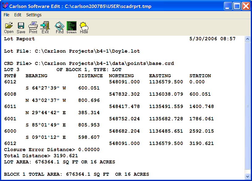
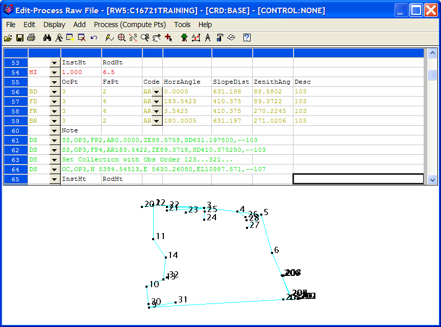
– Automated Plan Drafting from Field Data

– Generation of Surface Models, Roadways, Lots and Plans

– Full COGO Features

– Simple or Advanced Configurations

Carlson Survey
Carlson Survey

Show more categories

Customer Reviews

Carlson Survey Reviews

Joyce W.

Advanced user of Carlson Survey
★★★★★
Excellent Package Land Surveying Operations.

What do you like best?

The tool its easy to use and its available either as Standard Module or being part of the Civil Suite and offers many functional features.

I like the data storage flexibility of Carlson Survey and the fact that it can also operate within AutoCAD and even within IntelliCAD.

Carlson Survey its an Engineering tool for easy surveying operations for different project and it allows data exporting and even data uploading and downloading as well as easy tracking file history.

What do you dislike?

No anything to dislike on Carlson Survey, easy and very helpful tool for the Engineering projects.

Recommendations to others considering the product:

Flexible and functional Land Surveying platform. easy to set and it offers different capabilities to the Engineers for easy and productive Land Surveying projects.

What problems are you solving with the product? What benefits have you realized?

Effective Land Surveying, annotation and management of Engineering project documents and some more tool usage.

Review source: G2.com

Leave a reply

Your total score

B2B Software Guide